File:Quebec-map.png
No higher resolution available.
Quebec-map.png (280 × 230 pixels, file size: 15 KB, MIME type: image/png)
This is a file from the Wikimedia Commons. Information from its description page there is shown below.
Commons is a freely licensed media file repository. You can help. |

|
File:Québec, Canada.svg is a vector version of this file. It should be used in place of this PNG file when not inferior.
File:Quebec-map.png → File:Québec, Canada.svg
For more information, see Help:SVG. |
 |
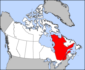
Map of Quebec (Canada)
Projection: Lambert azimuthal equal-area
Geospatial data from: The Atlas of Canada, The National Atlas of the United States and U.S. Geological Survey
Cartographer: John Fowler
| I, the copyright holder of this work, release this work into the public domain. This applies worldwide. In some countries this may not be legally possible; if so: I grant anyone the right to use this work for any purpose, without any conditions, unless such conditions are required by law. |
File history
Click on a date/time to view the file as it appeared at that time.
| Date/Time | Thumbnail | Dimensions | User | Comment | |
|---|---|---|---|---|---|
| current | 12:18, 24 March 2005 | | 280 × 230 (15 KB) | Voyager | Map of Québec Projection: Lambert azimuthal equal-area Geospatial data from: [http://atlas.gc.ca/ The Atlas of Canada], [http://www.nationalatlas.gov/ The National Atlas of the United States] and [http://www.usgs.gov U.S. Geological Survey] Cartograph |
File usage
The following page uses this file:
Global file usage
The following other wikis use this file:
- Usage on en.wikinews.org
- Liberal minority government elected in Quebec
- Overcrowded Montreal hospital asks public to stay away
- Accused killer of Canadian police officer released on bail
- Gilles Duceppe drops out of Parti Québécois leadership race
- 14 people injured after bus overturns in heavy rain near Quebec City
- Quebec man found not guilty in shooting death of Laval officer
- Usage on es.wikipedia.org
- Usage on fr.wikinews.org
- Usage on he.wikivoyage.org
- Usage on pl.wikivoyage.org
- Usage on su.wikipedia.org
- Usage on sv.wikivoyage.org
- Usage on test2.wikipedia.org
- Usage on uk.wikivoyage.org
- Usage on www.wikidata.org