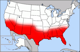
File:Map of USA highlighting Sun Belt.png

Map_of_USA_highlighting_Sun_Belt.png(280 × 183 pixels, file size: 40 KB, MIME type: image/png)

Public domain map courtesy of The General Libraries, The University of Texas at Austin, modified (by • Benc • 00:36, 13 Aug 2004 (UTC) to highlight regions.

Originally uploaded onto English Wikipedia 00:36, 13 August 2004 by Benc

English: This map come from the map collection of University of Texas, specifically from: [{{{url}}} {{{title}}}, from {{{origin}}}]. It is in the public domain (http://www.lib.utexas.edu/maps/faq.html#3.html).
Français : Cette carte est issue issu de la collection de cartes de l'université du Texas et plus précisément de celle-ci : [{{{url}}} {{{title}}}, from {{{origin}}}]. Elle se trouve dans dans le domaine public (http://www.lib.utexas.edu/maps/faq.html#3.html).
Nederlands: Deze afbeelding is afkomstig uit de kaartencollectie van de University of Texas. Deze kaarten bevinden zich in het publiek domein (http://www.lib.utexas.edu/maps/faq.html#3.html).
Public domain

This work is in the public domain in its country of origin and other countries and areas where the copyright term is the author's life plus 70 years or fewer.


You must also include a United States public domain tag to indicate why this work is in the public domain in the United States.

File history

Click on a date/time to view the file as it appeared at that time.

Date/TimeThumbnailDimensionsUserComment
current17:41, 27 September 2006Thumbnail for version as of 17:41, 27 September 2006280 × 183 (40 KB)Mr Bullitt~commonswikiPublic domain map courtesy of [http://www.lib.utexas.edu/ The General Libraries, The University of Texas at Austin], modified (by • Benc • 00:36, 13 Aug 2004 (UTC)) to highlight regions. Originally uploaded

There are no pages that use this file.

Global file usage

The following other wikis use this file: